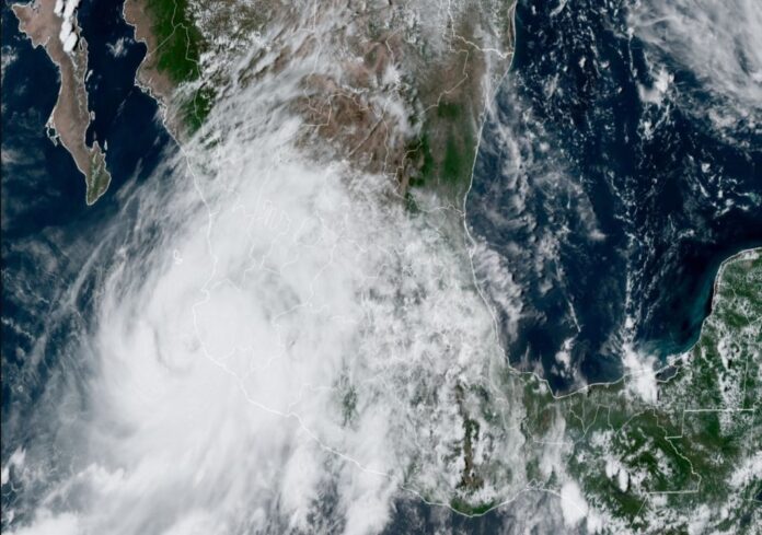
Hurricane “Nora” will favor torrential rains in several states of Mexico, in addition to hurricane-force winds and high waves.
During this weekend, tropical cyclone “Nora” will leave torrential rains, strong winds and high waves on the western coasts of the Mexican Republic. The trajectory forecast is towards the Sea of Cortez and the Baja California Peninsula, where its effects would also be felt.

Hurricane “Nora” was located at 1:00 p.m. this Saturday at 19.0 North, 105.4 West, approximately 155 kilometers south of Cabo Corrientes, Jalisco. It registered maximum winds of 140 km / h and a minimum central pressure of 977 hectopascals, being a category 1 hurricane on the Saffir-Simpson scale. Its trajectory was towards the north at a rate of 19 km / h towards the coast of Jalisco. Hurricanes “Nora” and “Ida” will be leaving torrential rains and intense winds in Mexico and the United States.
The predictions of the National Hurricane Center of the United States, indicate that “Nora” would reach the coastal area of Jalisco as a hurricane in the next few hours, and from this Sunday morning, it will be located off the coast of Nayarit. For the night of that same day, “Nora” will be located off the coast of Sinaloa and will enter the Sea of Cortez, still as a hurricane. It is likely that no later than this Wednesday it will reach Sonora as a tropical storm, where it will dissipate on land.
The circulation and influence of this tropical cyclone will give rise to torrential rains over the states of Guerrero , Michoacán , Jalisco , Colima , Nayarit , Sinaloa , Sonora and Baja California Sur . Winds greater than 120 km / h and waves of up to 5 meters high are also estimated in the coastal areas of the aforementioned states. It is recommended to be aware of the notices issued by the corresponding authorities.
Source: meteored.mx
Mexico Daily Post


